Christchurch Company Brings Artificial Intelligence to Wilding Conifer Control
Christchurch tech company Orbica has created an artificial intelligence (AI) system that could transform the battle against wilding conifers — invasive tree species which, left untouched, threaten to cover 20 per cent of the country within 20 years.
From the air, the trees look like tiny green dots, a scattered mass rapidly spreading through and colonising the high country. Each year, the Government spends millions of dollars controlling and removing wilding conifers; left unchecked, the trees disrupt native flora and fauna and blight our unique landscapes.
Enter Orbica, a Christchurch tech company with a geospatial focus.
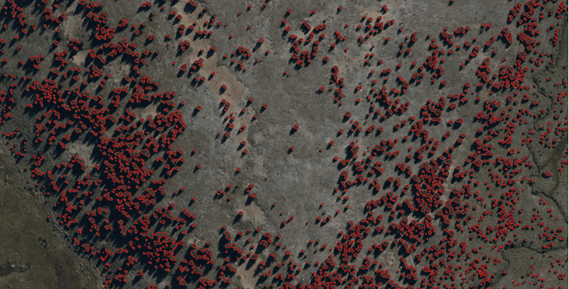
Last year, the growing firm was contracted by the Ministry for Primary Industries (MPI), one of the lead agencies delivering the National Wilding Conifer Control Programme, to develop software to remotely identify wilding conifers by analysing high-resolution aerial photography.

Orbica Team 2020
Orbica general manager - Delphine DucarugeOr you can automate. We saw a better way to do this with automation. It gives an accuracy of 90 per cent, which is probably as good as a human would get it.”
“You can get people to do that and sit on a chair and manually do these things — not many people want to do that!” Orbica general manager Delphine Ducaruge said.
“Or you can automate. We saw a better way to do this with automation. It gives an accuracy of 90 per cent, which is probably as good as a human would get it.”
It’s also far faster, as the system can process imagery across large swathes of the countryside using the power of AI.
Orbica is a leader in High Tech, one of four strength areas identified by the city as driving future growth and innovation. Since it was founded in 2017, the company has rapidly expanded to a team of about 30 people, including a German branch.
“We’re definitely growing quite fast, and we have no intention of stopping,” Ducaruge said.
Orbica calls the type of tech solution it developed for the wilding conifer control programme ‘GeoAI’ — a combination of deep learning algorithms and geospatial processing that automates feature detection and classification.
To teach the model to distinguish conifers, Orbica data scientist Sagar Soni said his team isolated features unique to the trees, like their shape and colour, then entered those thresholds into the system.

Wilding Conifer Control
It also involved a lot of painstaking work by an intern, who identified about 40,000 trees manually to train the model.
"She was like 'oh my God, I can see trees when I sleep’,” Ducaruge said.
The team, led by Soni, also identified false negative or false positive identifications made by the AI system and fed that data back in to further refine the process.
“It's a lot of work,” Ducaruge said. “But it's one of those things where once you build it you can just make it better."
The Department of Conservation supplied the photographs for the project, which were taken from a Cessna 180 airplane at sites around the country. Because of how high-resolution the imagery is, the system can identify small, ‘pre-coning’ trees with a canopy as small as 50 centimetres wide, meaning they can be treated before they seed and spread further. It can also distinguish between living and dead conifers, Soni said, and describe how big or small the trees are.
For the Government agencies, Soni said the GeoAI process would produce a heat map showing conifer density over an area, meaning they could use it to help prioritise control operations.
The National Wilding Conifer Control Programme is currently putting the system developed by Orbica through a year-long pilot.
Biosecurity New Zealand long term programmes manager - Sherman SmithThis remote detection technology has the potential to be really transformative for wilding control operations,”
“This remote detection technology has the potential to be really transformative for wilding control operations,” Biosecurity New Zealand long term programmes manager Sherman Smith said.
“It will mean we can map the location and density of wilding pines, which will reduce the need to search for them manually, allow us to identify the best control technique for a site, and allow us to monitor whether control has been successful.”
Ducaruge said the GeoAI approach could be used to automatically identify almost anything, as long as it could be seen from above and had some kind of recognisable pattern.
“You can find anything you want,” she said.
“The sky’s the limit.”


